Lake Hume this summer: which boat ramps work, and which licence you need either side of Bethanga Bridge
Every ramp on Goulburn-Murray Water's Lake Hume list was above its usable line at the last check, but the lake eases through summer, so the highest ramps need watching first, and the licence you need depends on the water: downstream of Bethanga Bridge (the main lake), Victoria requires one for any powered boat, and upstream of it (the Murray arm), NSW requires one from 10 knots or for any jet ski.
Lake Hume sat at 83.17% of capacity at Goulburn-Murray Water's 10 November update. That clears every boat ramp on GMW's list.
The highest-set of the 11 ramps is Tallangatta, which GMW lists as usable while the storage is above 51%. That leaves about 32 percentage points between the water and Tallangatta's line (our estimate: 83.17 minus 51). Every other ramp has more room than that.
The lake is easing, though, not filling. GMW's monthly figures peaked at 86.4% in September and have eased since, to 85.3% in October and 83.2% in November. GMW also says releases generally occur between December and May. As summer goes on, the ramps set highest are the first a falling lake reaches.
The other thing to settle before you tow is whose water you will be on. For boating, GMW splits the lake at Bethanga Bridge: downstream of the bridge (the main lake) is Victorian water, and upstream (the Murray arm) is NSW water. Victoria wants a licence for any powered vessel, whatever its speed. NSW wants one at 10 knots or more, or for any jet ski.
The lake is about 16 km east of Albury-Wodonga, an easy morning drive from a stay in the twin cities. This is the Albury Wodonga Motels guide to getting the boat in the water, and keeping it there legally, on both sides of the line.
Which Lake Hume ramps can you launch from?
The Lake Hume ramp gauge
GMW's Hume Dam page has today's figure.
above GMW's usable line below GMW's usable line
- Tallangatta 51% above GMW's usable line
- Hume Weir Park 47% above GMW's usable line
- Kookaburra Point south 45% above GMW's usable line
- Ebden high 42% above GMW's usable line
- Ebden mid 35% above GMW's usable line
- Bowna Waters high 31% above GMW's usable line
- Kookaburra Point north 29% above GMW's usable line
- Huon 20% above GMW's usable line
- Bowna Waters low 15% above GMW's usable line
- Lake Hume Resort 8% above GMW's usable line
- Kurrajong (Bulko Reserve) 6% above GMW's usable line
Typical answer: at 83.17% the water mark sits above all 11 ticks, so all 11 ramps show blue. Moved to 50%, only Tallangatta turns grey and the other 10 stay blue.
GMW publishes a storage level for each ramp. Above that level the ramp is usable; below it, it is not. Read from the top of the gauge, the lines are Tallangatta 51%, Hume Weir Park 47%, Kookaburra Point south 45%, Ebden high 42%, Ebden mid 35%, Bowna Waters high 31%, Kookaburra Point north 29%, Huon 20%, Bowna Waters low 15%, Lake Hume Resort 8% and Kurrajong (Bulko Reserve) 6%.
"Usable" is a measure of water at the ramp, not a promise of a free lane. GMW keeps the public ramps with the relevant council: Rural City of Wodonga, Towong Shire or Indigo Shire. It also notes that club leases can restrict public access.
The figure in this guide dates within days. On the morning you tow, open GMW's Hume Dam page and put its live percentage into the gauge above.
Why the lake keeps dropping through summer
Lake Hume storage, % of capacity, July to November 2026
Hume Dam runs on an annual cycle. The storage usually receives inflows during winter and fills by the end of spring each year. Then come the releases, and the dam is regularly drawn down to less than half of capacity by the end of autumn.
This year followed the pattern. GMW's monthly strip reads July 55.9%, August 76.2%, September 86.4%, October 85.3% and November 83.2%. The 10 November level of 189.34 m AHD sits about 2.66 m under the 192.0 m AHD full supply level (our working: 192.0 minus 189.34).
Nobody can name the day a ramp falls out of use, and we won't guess. One comparison is still worth having. GMW's usual end-of-autumn low of "less than half" is already under Tallangatta's 51% line. So if you plan to use Tallangatta, Hume Weir Park or Kookaburra Point south later in the season, check the level each time before you go.
Which side of Bethanga Bridge are you on?
Which side of Bethanga Bridge are you on?
- Downstream of Bethanga Bridge, the main lake. Victorian water (for boating): licence for any powered vessel, whatever its speed
- Upstream of Bethanga Bridge, the Murray arm. NSW water (for boating): licence at 10 knots or more, or for any jet ski; jet skis sunrise to sunset only
- Fishing, whole lake to Seven Mile Creek at Talmalmo: Victorian rules; Victorian licence or paid NSW fishing fee, exemptions apply
- Hume Dam wall at the western end; Albury-Wodonga, about 16 km west
Reciprocal licencing, registration and safety equipment regulations apply between both states (GMW).
Albury Wodonga already lives with a border down the middle: Cup Day is a holiday on one bank and not the other. Lake Hume has its own line. For boating, GMW divides the lake at Bethanga Bridge: downstream of the bridge (the main lake) is Victorian water, and upstream (the Murray arm) is NSW water.
Boats can be launched from several places, most of which are on the Victorian side. So the shore you launch from doesn't settle which state's rules you are under. The bridge does.
The two states do recognise each other: reciprocal licencing, registration and safety equipment regulations apply between both states. Fishing follows a different line, covered further down.
Do you need a boat licence on Lake Hume?
Licence check
Typical answer
A powered tinny trolling at under 10 knots upstream of the bridge gets "No boat licence needed in NSW water".
Switch the side to downstream of the bridge and the same boat at the same speed gets "Licence needed: Victorian water covers any powered vessel at any speed."
Fishing is separate: Victorian fishing rules apply to the whole lake; a Victorian licence or a paid NSW fishing fee covers you, exemptions apply.
Upstream of the bridge, in NSW water, you need a NSW boating licence to drive at 10 knots (18.5 km/h) or more, or to drive a jet ski. A powerboat under 10 knots needs none there.
That under-10-knot allowance stops at the bridge, because in Victoria anyone operating a powered recreational vessel requires a marine licence, whatever its speed.
Jet skis need a licence everywhere. GMW notes a jet ski licence is needed in either state, and in NSW a jet ski may run only between sunrise and sunset.
Teenagers can get behind the wheel in NSW, with limits. You can apply from age 12, and under-16s must not drive above 20 knots, at night, or while towing anyone. In NSW you must also carry your licence when driving at 10 knots or more or a PWC.
What changes when you boat in the other state's water?
A NSW licence holder crossing downstream is a visitor in Victoria. An interstate marine licence holder may operate the equivalent vessel in Victoria for a period of three months. That visitor must still follow Victorian rules, including speed limits and the wearing of lifejackets at certain times.
| Rule | Where it applies | What it says |
|---|---|---|
| Boat licence | NSW water, upstream of the bridge | Needed at 10 knots (18.5 km/h) or more, or for any PWC; carry it when driving at 10 knots or more or a PWC. |
| Boat licence | Victorian water, downstream of the bridge | Needed for any powered vessel, whatever its speed. |
| Jet ski | Both states | Licence needed in either state; in NSW water, only between sunrise and sunset. |
| Interstate licence | Victorian water | Holder may operate the equivalent vessel for three months, following Victorian rules including speed limits and lifejackets. |
| Reciprocity | Whole lake | Reciprocal licencing, registration and safety equipment regulations apply between both states. |
| Young drivers | NSW | Apply from 12; under 16s not above 20 knots, not at night, not while towing anyone. |
| Lifejackets | NSW water | Carry enough approved lifejackets for everyone on board; everyone on a PWC and anyone being towed wears Level 50S or above at all times. |
| Lifejackets | Victorian water | Children under 12 wear one in an open area of an underway boat; lifejackets required to be worn on vessels up to and including 4.8 m, and in circumstances of heightened risk on vessels up to 12 m. |
| Refuelling | Victorian water | Illegal with passengers on board, except where disembarking is impractical. |
| Skiing | Whole lake | Proper observer compulsory; no skiing after dark; distance-off rules apply even where no speed signs are posted. |
Lifejackets are where the two states differ most. In Victorian water, children under 12 must wear one in an open area of an underway boat, and lifejackets are required to be worn on vessels up to and including 4.8 m, and in circumstances of heightened risk on vessels up to 12 m.
In NSW water, a vessel must carry enough approved lifejackets for everyone on board, and everyone on a PWC, and anyone being towed, must wear Level 50S or above at all times.
Refuelling has its own Victorian rule. It is illegal to refuel a boat with passengers on board, except where disembarking is impractical. On a long summer day, that means a stop at the ramp, not a top-up mid-lake with the family aboard.
Which fishing licence covers Lake Hume?
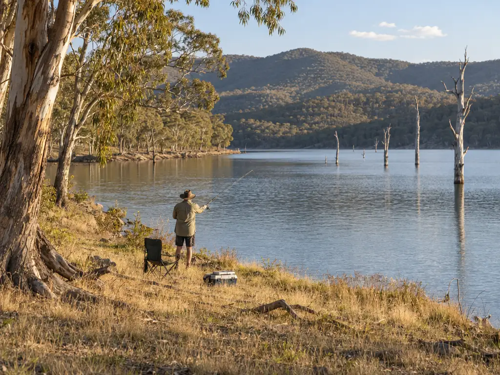
Fishing ignores the bridge. A Victorian fishing licence is required on Lake Hume, and Victorian regulations apply to the whole lake up to Seven Mile Creek at Talmalmo. If you have paid the NSW recreational fishing fee, you do not also need a Victorian licence: a reciprocal arrangement covers Lake Hume.
Not everyone needs one. Service Victoria says no licence is needed if you are under 18 or over 70. The exemptions also cover Aboriginal and Torres Strait Islander people, and Victorian or interstate equivalent Seniors Card holders.
If you see a fishing offence on the lake, GMW's page says to report it to Victorian Fisheries on 13 FISH (133474).
What to watch for below the surface
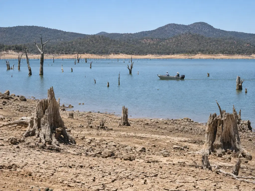
A drawn-down lake hides things. GMW warns of a risk of vessels colliding with submerged objects or running aground. A wake that was safe in spring can find a stump in February. Slow down near the shoreline and anywhere the water looks thin over the old timber.
GMW's low-water speed zone only arrives when the lake gets very low; distance-off rules apply at any level. No boating restrictions apply at Lake Hume while water levels are at or above 169.499 m AHD. Below that level, 5 knot restrictions apply south of Bethanga Bridge and north of an east-west line from the southern end of the dam embankment, and normal boating operations apply in other areas. The 10 November level sat about 19.8 m above that line (our estimate: 189.34 minus 169.499).
Skiers have three rules to keep. GMW says a proper observer is compulsory, skiing after dark is prohibited, and distance-off rules apply even where no speed signs are posted.
Making a Lake Hume day part of your stay
Before you tow
The lake is a short drive from town, so the best lake day starts early. You get the cooler hours of a summer morning, and time to sort the ramp before the heat builds.
Two checks belong on the morning itself. First, the level: open GMW's live page and compare it with your ramp's line. Second, the water quality: GMW's page sends readers to WaterNSW for the lake's blue-green algae status. Check it on the day, not the week before.
If you plan to camp rather than drive back, note that camping at Ludlow's Reserve is limited to 24 hours.
Summer holidays fall on different dates on each bank, and our guide to how the NSW and Victorian school calendars differ helps you pick a week that works for everyone. Boating with friends? The group accommodation tips cover booking several rooms together. For an evening off the water, see what to do on a weekend in Albury Wodonga.
Once you have your dates, book your room with Albury Wodonga Motels through our How to Book page. If you are towing, mention the boat trailer when you book, so you know where it will sit overnight before you arrive.